On this page
M6.9 Earthquake Strikes 15 km NNW of Pematangsiantar
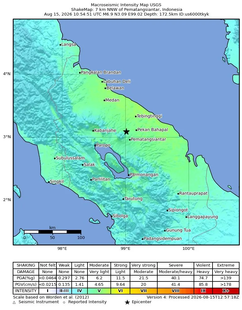
A powerful M6.9 earthquake struck 15 km NNW of Pematangsiantar, Indonesia, on August 15, 2026. The deep event occurred at a depth of 172.5 kilometers.
What Happened
A magnitude 6.9 earthquake, measured as a moment magnitude (mww), occurred on August 15, 2026, at 10:54 UTC.
The seismic event was centered 15 km NNW of Pematangsiantar, Indonesia.
Its hypocenter was recorded at a significant depth of 172.5 kilometers.
According to reports, at least 24 people indicated they felt the shaking.
The maximum reported intensity on the Modified Mercalli Intensity scale was MMI 5.19, with a perceived shaking intensity of CDI 4.3 based on community reports. More details are available on the USGS event page.
Impact
The United States Geological Survey, USGS, issued a green alert for this event, which suggests a low probability of casualties and damage.
Due to the earthquake's considerable depth, the energy of the seismic waves would have been dispersed over a larger area, potentially reducing ground shaking intensity at the surface compared to a shallower quake of similar magnitude.
Tsunami
Based on seismic data and the earthquake's characteristics, a tsunami was not generated by this event.
Deep earthquakes are less likely to displace the seafloor sufficiently to cause a tsunami.
Aftershocks
Earthquakes of this magnitude can often be followed by a series of aftershocks, which are smaller earthquakes occurring in the same general area.
Residents in the affected region should remain vigilant and follow local safety guidelines.
Tectonics of the Region
Indonesia is situated in a highly seismically active zone, specifically along the Pacific Ring of Fire, where multiple tectonic plates converge.
The region near Pematangsiantar, on the island of Sumatra, is influenced by the complex interaction of the Indo-Australian Plate subducting beneath the Sunda Plate.
This geological setting is responsible for frequent seismic activity, including both shallow crustal earthquakes and deeper-focus events within the subducting slab.
Earthquake Safety
During an earthquake, it is important to remember to Drop, Cover, and Hold On.
Drop to the ground, take cover under a sturdy table or desk, and hold on until the shaking stops.
If you are outdoors, move to an open area away from buildings, trees, and utility lines.
After the shaking subsides, check for injuries and damage, and be prepared for potential aftershocks.
For more comprehensive safety information, visit our Earthquake Safety Guide.
Related Reading
Understanding Earthquake Magnitudes
Learn about the different scales used to measure earthquake strength.
Earthquake Safety Guide
Essential tips to protect yourself and your family before, during, and after an earthquake.
Recent Earthquakes in Indonesia
Explore a list of recent seismic events in Indonesia.
USGS Event Page for us6000tkyk
View detailed scientific data and maps for this specific earthquake on the USGS website.
FAQ
Frequently Asked Questions
What was the magnitude of the earthquake?
The earthquake had a magnitude of 6.9, measured as a moment magnitude, mww.
Where did this earthquake occur?
The earthquake was located 15 km NNW of Pematangsiantar, Indonesia.
When did the earthquake happen?
The event occurred on August 15, 2026, at 10:54 UTC.
Was there a tsunami warning?
No, a tsunami was not generated by this earthquake, as indicated by seismic data.
How deep was the earthquake?
The earthquake had a depth of 172.5 kilometers.
How many people reported feeling the earthquake?
At least 24 people reported feeling the shaking from this earthquake.
Stay Informed on Global Seismic Activity
Sign up for our earthquake alerts to receive timely notifications about significant seismic events worldwide, directly in your inbox.