On this page
M7.4 Earthquake Strikes Choco, Colombia: What Happened
A magnitude 7.4 earthquake struck 5 km south of San Jose del Palmar in Choco, Colombia, on August 10, 2026, at an intermediate depth of 110 km.
What Happened?
A magnitude 7.4 earthquake, classified as an Mww (moment magnitude, W-phase) event by the U.S. Geological Survey, struck western Colombia on August 10, 2026, at 12:34 UTC (07:34 local time). The epicenter was located 5 km south of San Jose del Palmar, a small town in the department of Choco, at coordinates 4.844 N, 76.242 W.
USGS recorded the hypocenter at a depth of 110.3 km, an intermediate-depth event well below the shallow, thrust-faulting earthquakes more commonly associated with subduction-zone coastlines. The agency assigned the event a significance score of 1,612 and lists its review status as reviewed, its highest confidence level.
A moment tensor solution built from seismic waveform data indicates near-vertical, oblique faulting consistent with rupture inside the down-going Nazca Plate rather than on the shallow interface between plates. The centroid depth from the moment tensor solution, about 120.5 km, is broadly consistent with the origin depth reported for the event.
Impact and Felt Reports
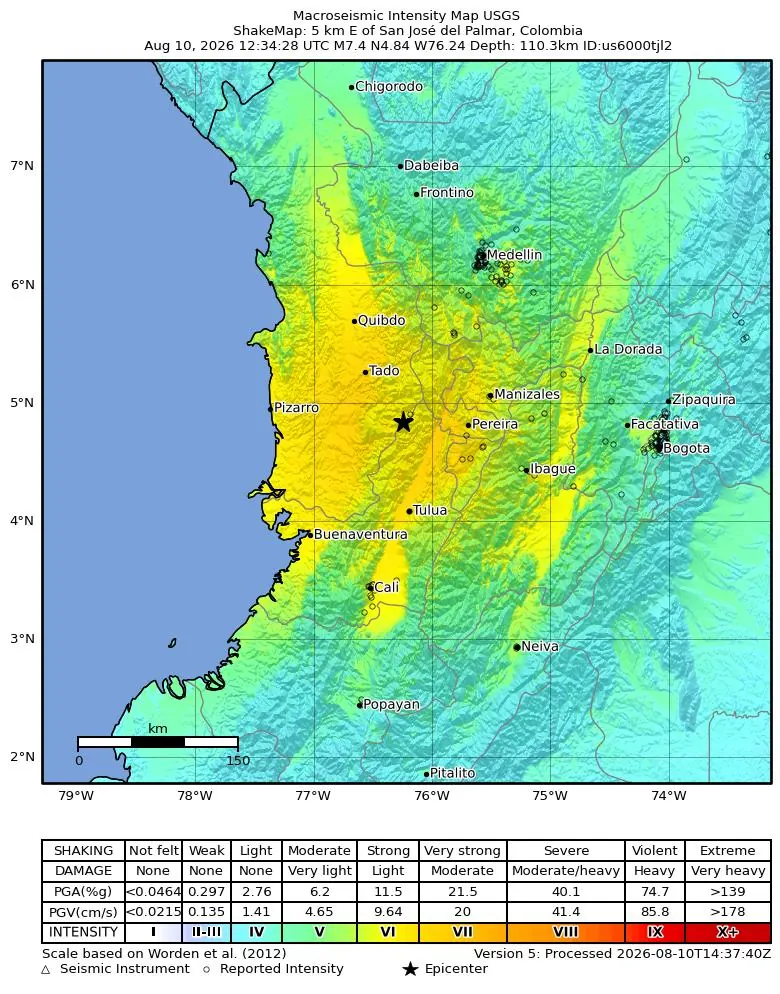
Despite its intermediate depth, the earthquake generated strong to very strong shaking across a wide area of western Colombia, according to USGS's automated ShakeMap, which modeled a maximum intensity of Modified Mercalli Intensity (MMI) VII near the epicenter. USGS population-exposure modeling estimates that roughly 1.6 million people experienced very strong shaking (MMI VII), about 8.9 million experienced strong shaking (MMI VI), and more than 17 million felt moderate shaking (MMI V) across Colombia and into neighboring Ecuador and Panama.
Cities closest to the epicenter recorded the highest modeled intensities, including Quibdo, the capital of Choco (population about 131,000, modeled MMI 6.5), Pereira (about 591,000, MMI 6.6), Armenia (about 301,000, MMI 6.5), and Buenaventura, Colombia's main Pacific port (about 424,000, MMI 6.2). Cali, Colombia's third-largest city with about 2.5 million residents, saw a modeled MMI of 6.2. Shaking was noticeably lighter but still widely felt in Medellin (population 2.5 million, modeled MMI 5.3) and in the capital Bogota (population about 8 million, modeled MMI 4.9), roughly 230 km east of the epicenter.
USGS's Did You Feel It? (DYFI) system had logged 775 felt reports by the time of publication, with a maximum Community Determined Intensity (CDI) of 7.9, corresponding to severe shaking near the epicenter. For more on how these community-reported intensity scales differ from earthquake magnitude, see our guide to magnitude vs. intensity.
Casualties, Damage, and Official Response
As of publication, no official reports of fatalities or confirmed structural damage had been released by Colombian authorities. This article will be updated if the Unidad Nacional para la Gestion del Riesgo de Desastres (UNGRD) or Colombia's Servicio Geologico Colombiano (SGC) publish official damage assessments.
USGS's PAGER system, which estimates likely impact rather than confirming it, placed the earthquake at an Orange alert level for both fatalities and economic losses. PAGER's automated summary notes that significant casualties and damage are likely and the disaster is potentially widespread, adding that past Orange-level alerts have required a regional or national level response, with estimated economic losses under 1% of Colombia's GDP.
PAGER also notes that the population in this region largely resides in structures vulnerable to earthquake shaking, with mud wall and wood, and other informal construction types predominant in Choco. PAGER's ground-failure models flagged a red-level liquefaction hazard, estimating that roughly 430,000 people live in areas modeled as prone to soil liquefaction, a secondary hazard where water-saturated ground temporarily loses strength during shaking, and an orange-level landslide hazard affecting a further 1,200 people in the steep terrain around the epicenter. These figures are model-based estimates, not confirmed field reports.
Tsunami Status
No tsunami was generated by this earthquake. USGS lists the tsunami flag for this event as inactive. The earthquake's intermediate depth of 110 km made it far less likely to displace the seafloor and trigger a tsunami, unlike shallow, shallow-dipping thrust earthquakes closer to the plate interface.
Large, shallow earthquakes near a coastline can trigger tsunamis when they cause sudden vertical displacement of the seafloor. This event's depth and rupture mechanism did not meet that threshold. For general guidance on responding to coastal earthquakes, see our tsunami safety guide.
Aftershock Activity
As of publication, USGS had recorded one aftershock of magnitude 4.0 or greater: a magnitude 5.0 event roughly 16 km west of San Jose del Palmar, about 44 minutes after the mainshock. This article will be updated as USGS records further aftershock activity.
Aftershock sequences following a large intermediate-depth earthquake typically decay over days to weeks, though additional moderate aftershocks are common in the following days. Residents in Choco, Risaralda, Valle del Cauca, and Quindio departments should expect continued aftershocks and follow guidance from Colombian civil protection authorities.
Tectonic Setting: Why Western Colombia Shakes
This earthquake occurred beneath western Colombia, where the Nazca Plate subducts eastward beneath the South American Plate along the Colombia-Ecuador Trench. Unlike shallow subduction-zone earthquakes that rupture the interface between the two plates, this event's depth of about 110 km places it within the subducting Nazca Plate itself, an intraslab earthquake caused by internal deformation of the plate as it bends and sinks into the mantle.
Intraslab earthquakes like this one can still be felt over a very wide area because seismic waves travel efficiently through the cold, rigid interior of a subducting plate, spreading strong shaking across a broader region than a shallow crustal earthquake of similar magnitude would produce, even though the shaking is typically less damaging directly above the epicenter than an equivalent shallow event. Learn more about how subduction and intraslab earthquakes work on our how earthquakes happen guide.
Colombia sits at the convergence of the Nazca, South American, and Caribbean plates, one of the most tectonically complex regions in South America, and has a long history of destructive earthquakes. USGS's historical comparison tool notes that a magnitude 6.1 earthquake struck about 76 km north of this epicenter on January 25, 1999, the Armenia-Quindio earthquake, which exposed roughly 398,000 people to intensity VII shaking and killed a reported 1,900 people. For an overview of seismic activity across the country, visit our Colombia earthquake tracker.
Earthquake Safety Guidelines
If you are in Choco, Risaralda, Valle del Cauca, or elsewhere near the epicenter, expect aftershocks in the hours and days ahead. During any earthquake, the recommended response is to Drop, Cover, and Hold On: drop to the ground, take cover under sturdy furniture, and hold on until the shaking stops.
Given the region's landslide and liquefaction hazards flagged by USGS, residents on steep slopes or near riverbanks should stay alert for ground movement following strong or prolonged shaking, and follow guidance from local UNGRD or municipal civil protection officials. For a full room-by-room breakdown of what to do during a quake, see our earthquake safety guide.
Related Reading
USGS Event Page: M7.4 us6000tjl2
Official event details, ShakeMap, PAGER, and moment tensor data from the United States Geological Survey.
Colombia Earthquake Tracker
Live earthquake activity and seismic risk information for Colombia.
Live Earthquake Map
Track aftershocks and earthquakes worldwide in real time on our interactive globe.
FAQ
Frequently Asked Questions
What was the magnitude of this earthquake?
The earthquake had a magnitude of 7.4 (Mww), as measured by the USGS.
Where was the epicenter located?
5 km south of San Jose del Palmar, Choco, Colombia, at 4.844 N, 76.242 W.
When did the earthquake occur?
On August 10, 2026, at 12:34 UTC (07:34 local time in Colombia).
How deep was the earthquake?
USGS recorded a depth of 110.3 km, an intermediate-depth earthquake within the subducting Nazca Plate.
Was a tsunami warning issued?
No. USGS recorded no tsunami generation for this event, consistent with its intermediate depth.
Were there any casualties or damage reported?
As of publication, no official reports of fatalities or damage had been released by Colombian authorities. USGS's PAGER system placed the event at an Orange alert, meaning significant, potentially widespread casualties and damage were considered likely.
Was the earthquake felt in Bogota, Medellin, or Cali?
Yes. USGS modeling shows moderate shaking in Bogota (MMI 4.9) and Medellin (MMI 5.3), and strong shaking in Cali (MMI 6.2), based on population-exposure modeling.
How many aftershocks followed the mainshock?
As of publication, USGS had recorded one aftershock of magnitude 4.0 or greater, a magnitude 5.0 event about 44 minutes after the mainshock.
Track Aftershocks in Real Time
Free iPhone app. Get push alerts for aftershocks and earthquakes worldwide.