On this page
M6.5 Earthquake Strikes Southwest of Balangonan, Philippines
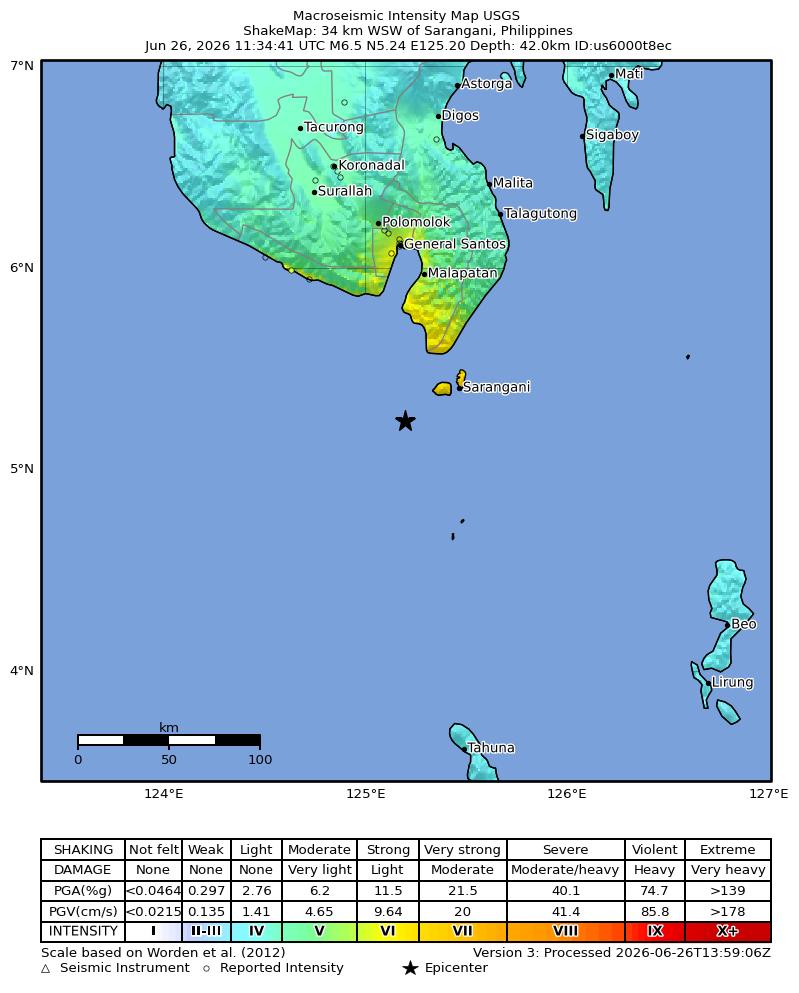
A magnitude 6.5 earthquake struck 35 km southwest of Balangonan, Philippines, on June 26, 2026, at a depth of 52.4 kilometers. The seismic event occurred at 11:34 UTC. There is no tsunami warning in effect.
What Happened
An earthquake with a magnitude of M6.5 struck 35 km southwest of Balangonan, Philippines, on June 26, 2026, at 11:34 UTC. The seismic event occurred at a depth of 52.4 kilometers. The earthquake's epicenter was located at coordinates 5.346°N latitude and 125.129°E longitude. The United States Geological Survey, USGS, assigned a significance rating of 657 to this event.
Impact and Felt Reports
The shaking from this earthquake was reportedly felt by 16 individuals across the region. The maximum intensity experienced, according to the Modified Mercalli Intensity, MMI, scale, was 6.08, indicating strong shaking in localized areas. The Community Internet Intensity Map, CDI, recorded a maximum intensity of 4.6. The United States Geological Survey, USGS, issued a green alert for this event, suggesting a low likelihood of casualties and damage.
Tsunami Status
Based on current assessments, a tsunami is not expected following this earthquake. There is no tsunami warning or advisory in effect for this event.
Aftershocks
Aftershocks are common occurrences following a significant earthquake like this one. These smaller tremors can continue for hours, days, or even weeks after the main event. Residents in affected areas should remain vigilant and prepared for potential follow-up seismic activity.
Tectonic Setting
The Philippines is situated in a highly active seismic zone known as the Pacific Ring of Fire. This region is characterized by frequent earthquakes and volcanic activity due to the interaction of several major tectonic plates. Earthquakes in this area are a result of these complex plate movements and subduction processes, where one tectonic plate slides beneath another.
Earthquake Safety Tips
During an earthquake, remember to Drop, Cover, and Hold On. Drop to the ground, take cover under a sturdy piece of furniture, and hold on until the shaking stops. If you are outdoors, move to an open area away from buildings, trees, and power lines. After the shaking subsides, check for injuries and assess your surroundings for potential hazards or structural damage. Always have an emergency kit ready and a family communication plan in place.
Related Reading
Understanding Earthquake Alerts
Learn what different earthquake alert levels, like green, yellow, orange, and red, signify and how they are determined.
Philippines Earthquake Preparedness
Official guidelines and resources from PHIVOLCS, the Philippine Institute of Volcanology and Seismology, on preparing for earthquakes.
What is a Subduction Zone?
Explore the geological processes behind subduction zones, which are common along the Ring of Fire and cause many powerful earthquakes.
FAQ
Frequently Asked Questions
What is earthquake magnitude?
Earthquake magnitude is a measure of the energy released at the source of the earthquake. It is determined from the seismic waves recorded on seismographs. The Richter scale is a famous example, but modern seismology uses more precise scales like moment magnitude, mww, to measure larger quakes.
What is the difference between magnitude and intensity?
Magnitude describes the size of the earthquake at its source, while intensity describes the strength of ground shaking at a particular location. Intensity is often measured using the Modified Mercalli Intensity, MMI, scale and can vary greatly depending on distance from the epicenter, local geology, and building types.
What should I do during an earthquake?
During an earthquake, the safest action is to Drop, Cover, and Hold On. Drop to the ground, take cover under a sturdy desk or table, and hold on until the shaking stops. Stay away from windows, heavy furniture, and other items that could fall.
Are aftershocks dangerous?
Yes, aftershocks can be dangerous. While generally smaller than the main earthquake, strong aftershocks can cause further damage to already weakened structures and pose a risk to people. It is important to remain vigilant and follow safety guidelines after a major quake.
What is the Pacific Ring of Fire?
The Pacific Ring of Fire is a major area in the basin of the Pacific Ocean where a large number of earthquakes and volcanic eruptions occur. It is a horseshoe-shaped belt that is home to over 75% of the world's active and dormant volcanoes and experiences about 90% of the world's earthquakes. It is formed by the movement and collision of several tectonic plates.
Stay Informed
Sign up for earthquake notifications to receive real-time alerts and updates on seismic activity in your region or areas of interest.