On this page
Venezuela M7.5 Earthquake June 2026: What Happened and Why
On June 24, 2026, twin earthquakes struck the northern coast of Venezuela near Yumare: a M7.2 foreshock followed 39 seconds later by a M7.5 mainshock. At least 32 people were killed, over 700 injured, and the La Guaira coastal state was declared a disaster zone.
On the evening of June 24, 2026 (22:05 UTC), two powerful earthquakes struck the northern coast of Venezuela in rapid succession, causing building collapses in Caracas and along the northern coastal corridor. The sequence is the most destructive seismic event in Venezuela in nearly three decades. Track current aftershock activity on the live earthquake map.
What Happened
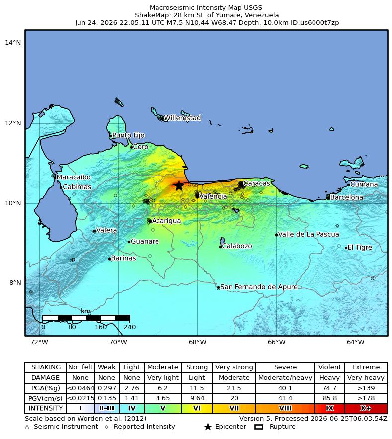
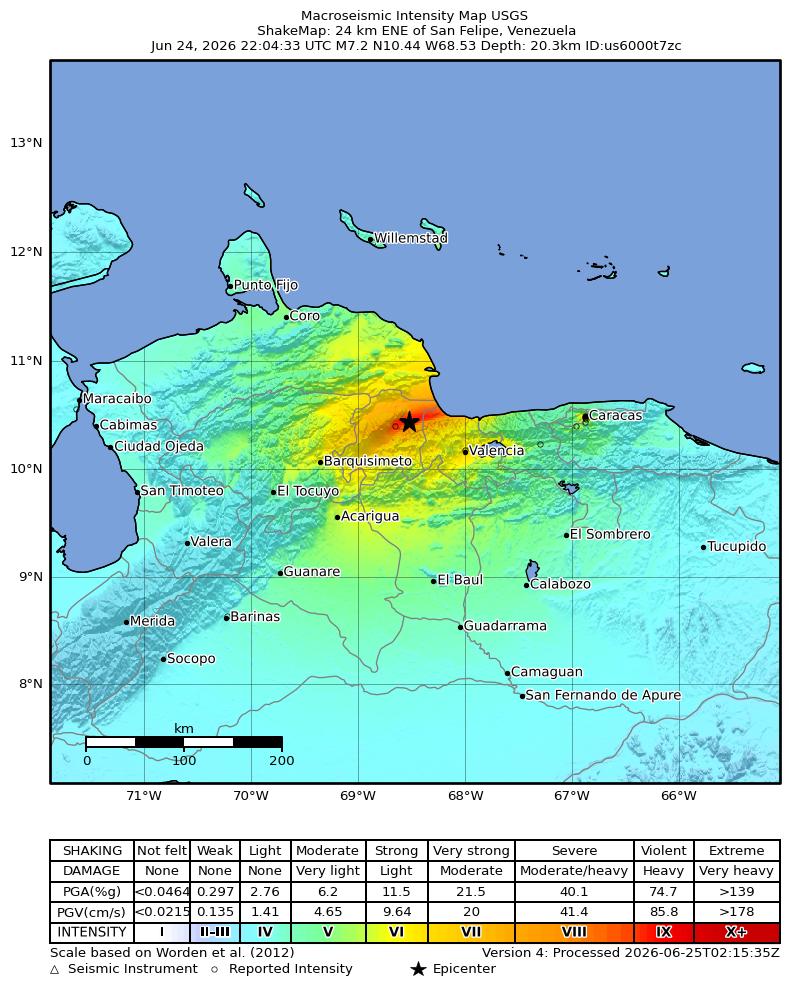
At 22:04 UTC, a M7.2 foreshock (USGS ID us6000t7zc) struck near San Felipe, in Yaracuy state, approximately 284 km west of Caracas. Thirty-nine seconds later, the mainshock arrived: a M7.5 earthquake (mww, USGS ID us6000t7zp), centered 28 km southeast of Yumare at coordinates 10.435 N, 68.472 W and a depth of 10 km.
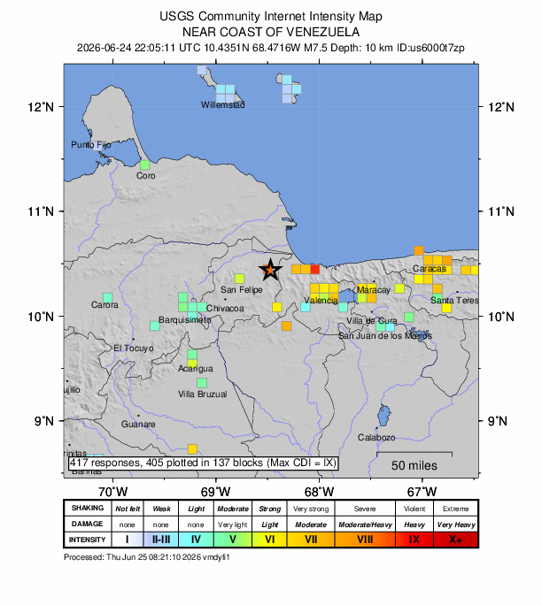
The shallow focus (10 km depth is near the minimum for tectonic events) amplified ground shaking at the surface. USGS ShakeMap estimated Modified Mercalli Intensity (MMI) values of approximately 8.9 (Severe to Violent) near the epicenter. The agency's PAGER system issued a RED alert, indicating high confidence of significant casualties and the likelihood of losses requiring major international response. USGS received 413 felt reports within hours of the mainshock.
Event Summary
- Mainshock magnitude
- M7.5 (mww)
- Foreshock magnitude
- M7.2 (mww)
- Date and time
- June 24, 2026, 22:05 UTC
- Depth
- 10 km (shallow)
- Epicenter
- 28 km SE of Yumare
- USGS PAGER alert
- RED
- USGS event ID
- us6000t7zp
- Felt reports
- 413 (CDI 8.7)
Source: USGS Earthquake Hazards Program
Impact and Damage
Preliminary figures from Venezuelan civil protection authorities and international news agencies reported at least 32 deaths and more than 700 injuries as of the hours following the mainshock. These figures are expected to rise as search-and-rescue operations continue in collapsed structures. USGS PAGER's probabilistic model indicated a substantial probability of the final death toll exceeding 10,000 given building vulnerability in the affected region.
La Guaira state, on the northern Caribbean coastline immediately north of Caracas and home to the country's main international airport, sustained the heaviest reported structural damage and was declared a disaster zone by Venezuelan authorities. Building collapses were also reported in Caracas itself and in communities in Yaracuy and Carabobo states.
Infrastructure damage included disruptions to road access along the Caracas-La Guaira corridor, which is carved into steep terrain prone to landslides during seismic events. Power outages were reported across the affected region.
Tsunami Warning
Following the M7.5 mainshock, the Pacific Tsunami Warning Center issued a tsunami watch for Puerto Rico and the U.S. Virgin Islands. The watch was subsequently canceled within approximately one hour after sea-level monitoring stations confirmed no destructive tsunami wave was propagating across the Caribbean.
No major tsunami impact was reported on any Caribbean coastline. The event geometry - a predominantly strike-slip fault rupture rather than vertical seafloor displacement - limited the tsunami-generating potential. However, local wave disturbances were possible near the Venezuelan coast in the immediate aftermath of the earthquake.
For coastal communities near active fault zones, the standard guidance applies: if you feel strong sustained shaking near the coast, move immediately to high ground without waiting for an official warning. Read more on the earthquake and tsunami safety page.
Aftershocks
A M4.5 aftershock (USGS ID us6000t80d) was recorded 13 km north of Caucaguito shortly after the mainshock. Aftershock sequences following M7.5 events typically include multiple M5+ events over hours to days, with diminishing frequency over subsequent weeks.
Residents in affected areas should expect continued aftershocks and avoid re-entering damaged structures. Aftershocks can sometimes cause further collapse of already-weakened buildings. The USGS maintains a real-time aftershock catalog at the event page.
Why Venezuela Has Large Earthquakes
Northern Venezuela sits along the boundary between the Caribbean plate and the South American plate, one of the most seismically active tectonic boundaries in the western hemisphere outside the main Pacific Ring of Fire.
Three major right-lateral strike-slip fault systems dominate the region. The El Pilar Fault runs along the northeast coast from Trinidad westward through the Gulf of Paria. The Boconó Fault crosses the Andes of western Venezuela. The San Sebastian Fault lies offshore of the central north coast, roughly where the June 2026 sequence originated. These faults accommodate the eastward motion of the Caribbean plate relative to stable South America at roughly 2 cm per year.
Historically significant earthquakes on these fault systems include the 1812 Caracas earthquake (M~7.0, estimated 15,000-20,000 deaths), the 1900 San Narciso earthquake (M7.7), and the 1967 Caracas earthquake (M6.5, approximately 240 deaths). The Venezuela earthquake page lists the full historical record with magnitude, location, and casualty data.
Earthquake Safety Reminders
During an earthquake, the recommended action is Drop, Cover, and Hold On: drop to hands and knees, take cover under a sturdy table or against an interior wall away from windows, and hold on until shaking stops. Do not run outside during shaking.
- If near the coast and shaking is strong and prolonged, move to high ground immediately. Do not wait for an official tsunami warning.
- After shaking stops, check for fires, gas leaks, and structural damage before re-entering a building.
- Expect aftershocks. Damaged buildings can collapse during aftershocks smaller than the mainshock.
- Follow official communications from Venezuelan civil protection authorities (Protección Civil) and FUNVISIS (Fundación Venezolana de Investigaciones Sismológicas).
For a complete earthquake preparedness guide, visit the safety page.
Related Reading
FAQ
Frequently Asked Questions
How large was the Venezuela earthquake on June 24, 2026?
The mainshock measured M7.5 (mww) and struck 28 km southeast of Yumare at 22:05 UTC. A M7.2 foreshock preceded it by approximately 39 seconds near San Felipe. The USGS assigned a RED PAGER alert, the highest tier, indicating a high probability of significant casualties and economic losses.
Was there a tsunami warning for the Venezuela earthquake?
Yes. A tsunami watch was briefly issued for Puerto Rico and the U.S. Virgin Islands after the M7.5 strike. It was canceled within roughly one hour when monitoring confirmed no destructive tsunami wave had been generated. The shallow depth (10 km) did create brief concern for Caribbean island coasts.
Why does northern Venezuela have major earthquakes?
The northern Venezuelan coast sits on the boundary between the Caribbean plate and the South American plate. Three major right-lateral strike-slip fault systems - El Pilar, Boconó, and San Sebastian - run close to the coast and through populated interior areas. Stress accumulates and periodically releases in large earthquakes.
What is the USGS PAGER alert and what does RED mean?
PAGER (Prompt Assessment of Global Earthquakes for Response) is a USGS system that estimates probable casualties and economic losses within minutes of a major earthquake. A RED alert means the event is likely to cause high casualties and economic losses requiring significant international response. The June 24, 2026 Venezuela earthquake received a RED alert.
Where can I track aftershocks from the Venezuela earthquake?
The USGS event page (earthquake.usgs.gov/earthquakes/eventpage/us6000t7zp) lists all aftershocks in real time. Earthquake Globe shows every M1.0+ event on an interactive 3D globe. A M4.5 aftershock struck 13 km north of Caucaguito shortly after the mainshock (USGS ID us6000t80d).
Track Venezuela Aftershocks in Real Time
Free iPhone app. Set a M4.0+ alert for Venezuela and get notified for every aftershock.